Wednesday, March 19, 2014

Chile


As it turns out, Chile is even more expensive than Costa Rica. So my time here will be short and exceptionally low key, I will be doing things that are free or at least of the ultra-low cost variety.


Chile lies west of the Andes, between the foothills of the Andes Mountains and the Pacific Ocean. For some reason, I thought that it would be a country of high cliffs and rugged mountains, but it is a country of barren sand, rainless weather, and a long way between nowhere at least as far south as Santiago. This has been common to what I have seen since I left Ecuador. At least Peru has the advantage of the Amazon Region on the eastern side of the Andes, which Chile does not have. So if you are a giant fan of dry, plant less land, with bright sunny days; Chile is for you.


I was hoping to move on into the southern part of Argentina next, but it is as expensive as Chile this time of year, add to that the $180US Reciprocity Fee charged when entering it is now over my $1200 US budget I have for each month. I will have to turn around start heading back north and for home on the 26th of March 2014. That means there are 4 countries in South America that charge $130US or more for United State Citizens to enter them; Bolivia, Paraguay, Brazil and Argentina (this is of course in return what we charge them to come to the states). 


Santiago is at an elevation of only 520 m (1,706 ft) with a mild climate and is the capital of Chile. Santiago founded in 1541 and has been the capital city since colonial times. The city has a downtown core of 19th century neoclassical architecture and winding side-streets, dotted by art deco, neo-gothic, and other styles. Santiago's cityscape is shaped by several stand-alone hills and the fast-flowing Mapocho River. Mountains of the Andes chain can be seen from most points in the city. These mountains contribute to a considerable smog problem, particularly during winter. The city outskirts are surrounded by vineyards, and Santiago is within a few hours of both the mountains and the Pacific Ocean.


My time in Santiago has been intriguing; it has an extensive transit system of Metro (subway) and a large network of surface street buses. The city looks to be well planned out with many sub zones, city parks, and a wide variety of restaurants, pubs, nightclubs, cinemas, performing arts, sports and shopping. Santiago has good streets with few potholes and wide sidewalks with easy walking and wheelchair ramps all over the city. 


I have found the people here to be friendly and mostly well dressed (not much saying poor) giving the impression of a not being a “3rd world country” but more of a modern metropolis. I am sorry to say I have not found much in the way of street food here. Too bad, I do love eating the local people’s food. Now, I will just have to wait until I start going back north of Peru, the more north the better.


Monday, March 3, 2014

Machu Picchu, City of the Incas, Cuzco, Peru


 Machu means old, and Picchu means peak, so we have Old Peak. The Inca site built in the 15th century, at about 8000 feet above sea level and located in Cusco a sacred valley which lies 50 miles NW of the current city of Cusco. It is thought that this site built for the Inca Emperor Pachacuti (1438-1472) and is sometimes mistakenly referred to as the “Lost City of the Incas”.

The estate built around 1450 but abandoned around the time of the Spanish Conquest, a century later. It seems that the Spanish did not know of this site, so it remained undisturbed.


Not known to the outside world till 1911 when an American historian, Hiram Bingham, brought international attention to it.


It became a UNESCO World Heritage Site in 1983. Then in 2007, Machu Picchu was voted one of the New Seven Wonders of the World in a worldwide Internet poll.


From what I have seen of this site and the Inca descendants,  short stocky people that are strong and proud. They continue to live and farm in some of the most rugged and inhospitably steep land. I have seen these people clear and farm this land by hand; a backbreaking labor intensive effort that has gone on for centuries.  


An Inca bridge was built to the west of Machu Picchu, the tree-trunk bridge, at a location where a gap occurs in the cliff that measures 6 meters (20 ft). It could be bridged by two tree trunks, but with the trees removed, there was 570 meters (1,870 ft) fall to the base of the cliffs.

Friday, February 21, 2014

Dr. Maria Reiche: Great Lady of Nazca


Nazca has the driest desert in the world; it only gets one hour of rain each year and that is more of a drizzle than a rain. The water the people use flows from the Andes Mountains and an underground water source that is down over 15 meters. The rainy season is only 6 weeks long in February and March. It has been dry for two years now.

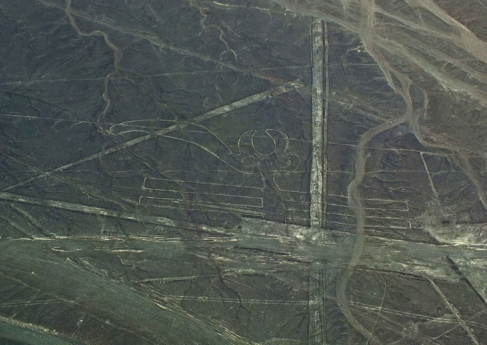
The lines are shallow designs made in the ground by removing the reddish pebbles and uncovering the white ground underneath. Many are simple lines or geometric shapes; more than seventy are zoomorphic designs of animals such as birds, fish, llamas, jaguar, monkey, or human figures. Other designs include phytomorphic shapes such as trees and flowers, the largest figures are over 200 meters (660 ft) across. Scholars differ in interpreting the purpose of the designs, but in general they ascribe religious significance to them.

In 1939, Maria was teaching in Lima, the capital of Peru, and doing scientific translations. By then, Germany was already at war in Europe, so she did not want to go back to her home country. Then Maria heard from an American scientist in Lima about the mysterious Lines and Figures of Nazca, which he had recently seen from an airplane. She was intrigued enough to take a flight herself in a small plane over the Nazca desert. When she saw the figures from the airplane of the spider, the hummingbird and the monkey, she was so fascinated by them that she moved to Nazca to study the lines herself.


Maria made many flights, taking photographs of all the etchings on the desert floor. She was especially drawn to the image of the monkey, but when she enlarged the photos she had taken, she was amazed to see that one hand had only four fingers just like her. Due to an infection in Maria’s hand she too lost one of her fingers to gangrene. At that time, she had not even heard about the Lines of Nazca.
 
She asked people who knew the old Nazca stories what this might have meant. Finally, she learned that this was a mark of the God of Thunder, which gave significant power to communicate with the gods. Had Maria, herself, been marked to uncover the secrets meant only for the gods?


Maria Reiche (1903–1998) was a German mathematician, archaeologist, and technical translator who carried out research into the Nazca Lines in Peru, beginning in 1940, and had success in gaining recognition and preservation of the property. She helped educate people about the resource and gain government recognition and preservation. In 1995, the Nazca Lines were declared a UNESCO World Heritage Site.

Maria Reiche - Astronomical Theory

Maria Reiche, the most famous Nazca-Researcher, prefer the astronomical theory. Lines should show in the direction of the rising of influential stars and planetary events like summer and winter solstices. Formations like the spider and the monkey could show star constellations like Orion and Ursa Mayor (Big Dipper).

The big problem of all astronomical theories is that age is unknown. The direction of stars change over the centuries because the phenomena of precession.

Maria Reiche has led a determined effort to discredit the von Daniken theory of extraterrestrials. The strategy of this attack has been to argue that the Nazca Indians constructed the lines relatively recently - sometime between 300 BC and 800 AD. In support of this possibility, some scientists have put forward ingenious ideas on how the geoglyphs could have theoretically been designed from the ground. The important evidence, however, that attempts to link the lines definitively to the Nazcan culture. Here, neither of the two key pieces of evidence survives scrutiny.

As it stands today the truth and origin of these lines is still unknown and may never be known.

Maria Reiche lived her last 25 years rent free at the Nazca Lines Hotel; where they also constructed the Maria Reiche Planetarium. They hold nightly shows in four different languages to explain Maria’s ties between the stars and the Nazca Lines.

Tuesday, February 18, 2014

Ancient Geoglyphs, Nazca Lines, Nazca, Peru


The Nazca Lines are a series of ancient geoglyphs located in the Nazca Desert, in southern Peru. They were designated as a UNESCO World


Heritage Site in 1994. The high, arid plateau stretches more than 80 kilometres (50 mi) between the towns of Nazca and Palpa on the Pampas de Jumana about 400 km south of Lima. Although some local geoglyphs resemble Paracas motifs, scholars believe the Nazca Lines were created by the Nazca culture between 800 BC and 800 AD. The hundreds of individual figures range in complexity from simple lines to stylized hummingbirds, spiders, monkeys, fish, sharks, orcas, and lizards. 
Whale

Astronaut 


The lines are shallow designs made in the ground by removing the reddish pebbles and uncovering the whitish/grayish ground beneath. Hundreds are simple lines or geometric shapes; more than seventy are zoomorphic designs of animals such as birds, fish, llamas, jaguar, monkey, or human figures. Other designs include phytomorphic shapes such as trees and flowers. The largest figures are over 200 meters (660 ft) across. 

Monkey 
Hummingbird


Scholars differ in interpreting the purpose of the designs, but in general they ascribe religious significance to them. Other theories have been summarized as follows: "The geometric ones could indicate the flow of water or be connected to rituals to summon water. The spiders, birds, and plants could be fertility symbols. Other possible explanations include: irrigation schemes or giant astronomical calendars."


Spider
Due to the dry, windless, and stable climate of the plateau and its isolation, for the most part the lines have been preserved. Extremely rare changes in weather may temporarily alter the general designs. As of recent years, the lines have been deteriorating due to an influx of squatters inhabiting the lands. Archeologists, ethnologists, and anthropologists have studied the ancient Nazca culture to try to determine the purpose of the lines and figures. One hypothesis is that the Nazca people created them to be seen by their gods in the sky. Kosok and Reiche advanced a purpose related to astronomy and cosmology: the lines were intended to act as a kind of observatory, to point to the places on the distant horizon where the sun and other celestial bodies rose or set in the solstices. 


Many prehistoric indigenous cultures in the Americas and elsewhere constructed earthworks that combined such astronomical sighting with their religious cosmology, as did the later Mississippian culture at Cahokia in present-day United States. Another example is Stonehenge in England. But Gerald Hawkins and Anthony Aveni, experts in archaeoastronomy, concluded in 1990 that there was insufficient evidence to support such an astronomical explanation. Reiche asserted that some or all of the figures represented constellations. By 1998, Phyllis B. Pitluga, a protégé of Reiche and senior astronomer at the Adler Planetarium in Chicago, had concluded that the animal figures were "representations of heavenly shapes. But she contends that they are not shapes of constellations but of what might be called counter constellations, the irregular-shaped dark patches within the twinkling expanse of the Milky Way." Aveni criticized her work for failing to account for all the details. 

Parrot
In 1985, the archaeologist Johan Reinhard published archaeological, ethnographic, and historical data demonstrating that worship of mountains and other water sources predominated in Nazca religion and economy from ancient to recent times. He theorized that the lines and figures were part of religious practices involving the worship of deities associated with the availability of water, which directly related to the success and productivity of crops. He interpreted the lines as sacred paths leading to places where these deities could be worshiped. The figures were symbols representing animals and objects meant to invoke the gods' aid in supplying water. The precise meanings of many of the individual geoglyphs remain unsolved as of 2013. 

Hands or Frog and Tree
Henri Stierlin, a Swiss art historian specializing in Egypt and the Middle East, published a book in 1983 linking the Nazca Lines to the production of ancient textiles that archeologists have found wrapping mummies of the Paracas culture. He contended that the people may have used the lines and trapezes as giant, primitive looms to fabricate the extremely long strings and wide pieces of textile that are typical of the area. By his theory, the figurative patterns (smaller and less common) were meant only for ritualistic purposes. This theory is not widely accepted, although scholars have noted similarities in patterns between the textiles and the Nazca Lines, which they take as sharing in a common culture. 

Phyllis Pitluga, senior astronomer at the Adler Planetarium & Astronomy Museum and a protégé of Reiche, did computer-aided studies of star alignments. She asserted that the giant spider figure is an anamorphic diagram of the constellation Orion.


This information was gathered from Wikipedia, while I was in Nazca, Peru.